The post IF YOU LIKE MANHATTAN, YOU’LL LOVE MENHADEN (for fishing around NY Harbor) appeared first on New York Harbor Channel.
]]>
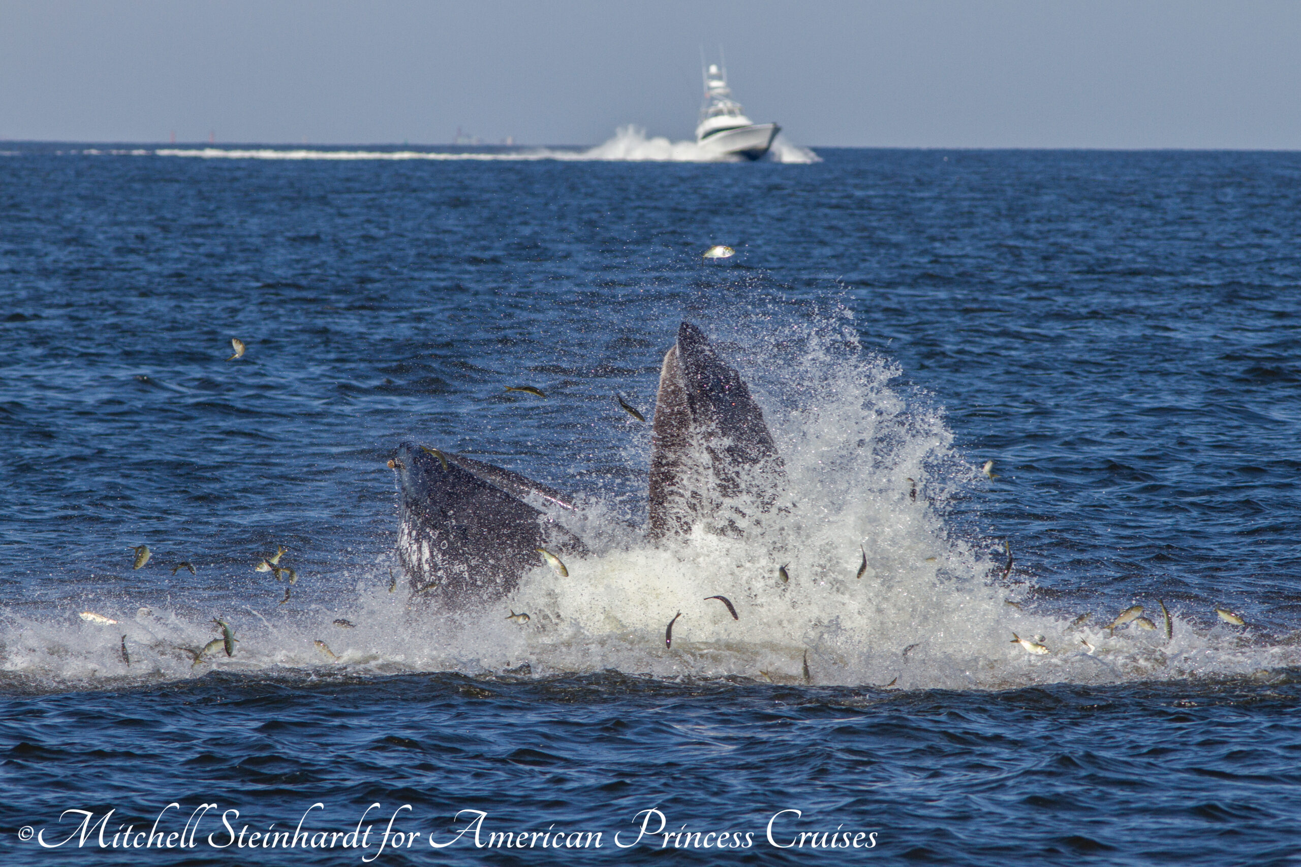
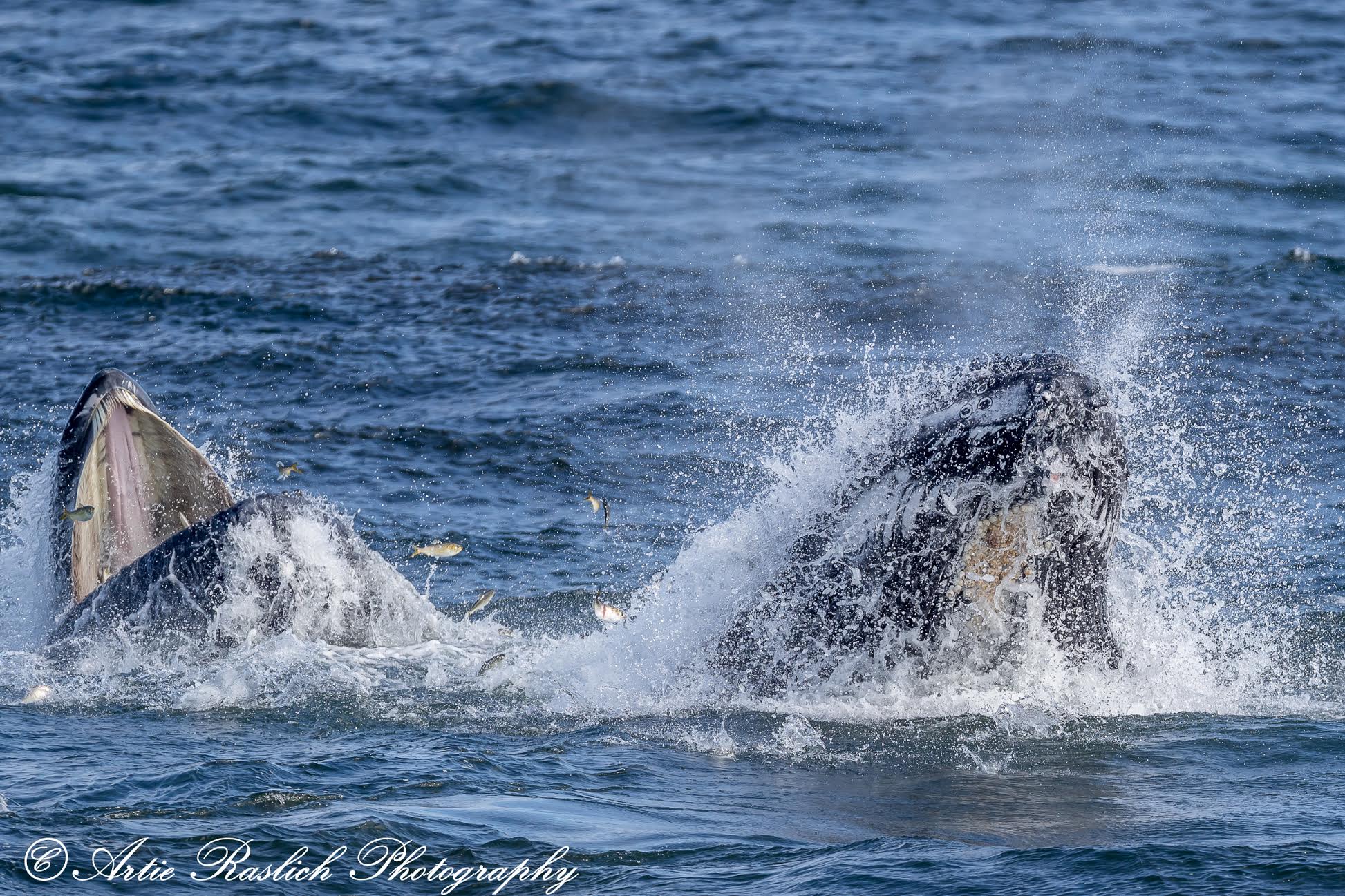
The most desired bait for fishermen of Long Island and New Jersey is known as bunker. Bunker is a colloquial name for the species known as the Atlantic Menhaden. Menhaden is a forage fish that is essential for the ocean food web. Unfortunately for them, every larger fish and mammal swimming in the New York Bight (the sea east and south of New York Harbor) thrive on Menhaden. Local fishermen are disturbed to hear that bunker numbers in the Bight diminish because of industrialized fishery as it has a direct correlation on the number of larger game fish populating their favorite fishing spots. Earlier this decade, the decline was especially traumatic.
However, with warmer waters over the past five years, there has been an uptick in the menhaden population. As climate change has moved Caribbean and Gulf water species northward, the entire ecosystem has also shifted in this northerly direction up the U.S. coastline. Most significantly, lobsters off New England have moved into Canadian waters to find the cooler temperatures on the ocean floor. Recently, warm-water sharks typically abundant off of Florida and the Carolina’s are now visiting Long Island. Of course, another contributing factor is that the sharks may be following the greater numbers of menhaden migrating up to New York and New England.
As a result, Americans are getting their lobsters from Canada, tuna fishing boats coming out of Montauk are filled to capacity, and the incidence of shark sightings are breaking records along Long Island beaches.
WHALES LOVE MENHADEN
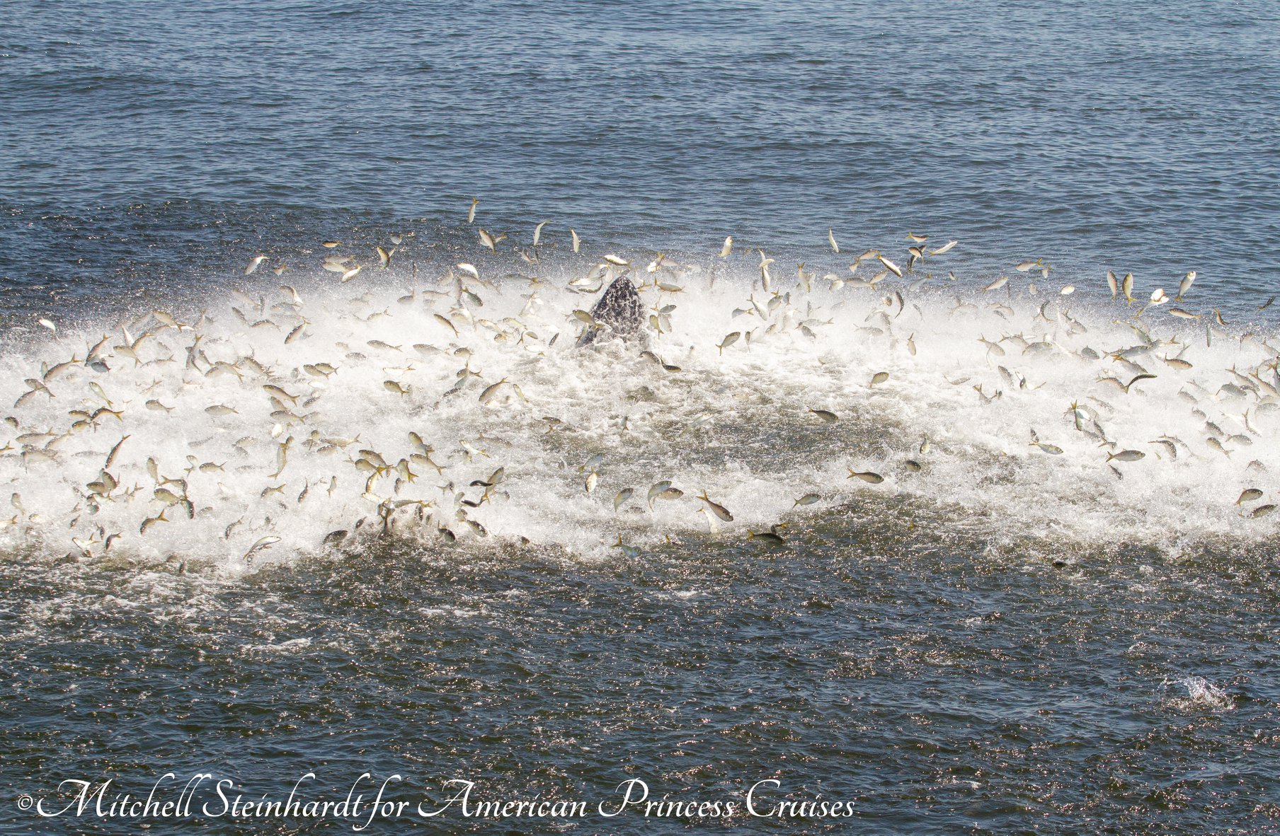
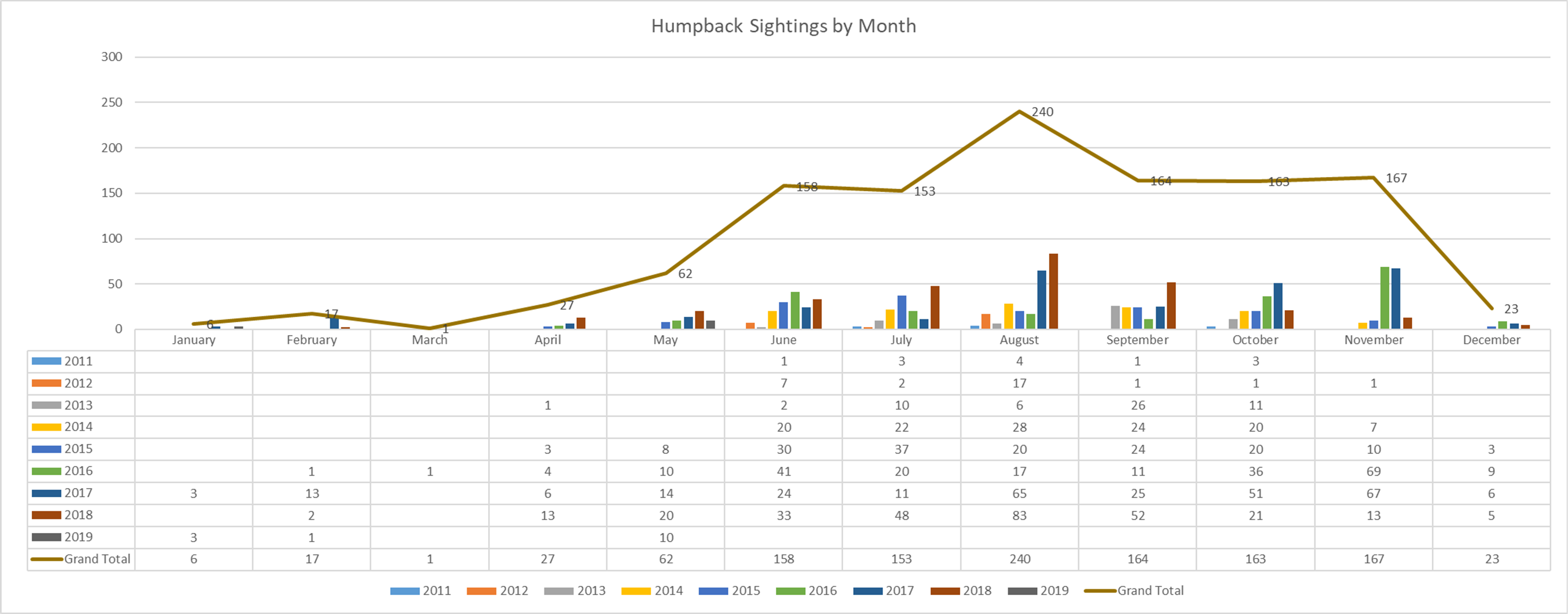
The whale population in the New York Bight has also been on the increase. More humpbacks are regularly feeding on menhaden. The presence of whales outside of New York City is now commonplace and it is no longer seasonal. Monitoring devices such as the Melville buoy built by the Woods Hole Oceanographic Institute identify humpbacks, sei, fin, and right whales throughout the year.
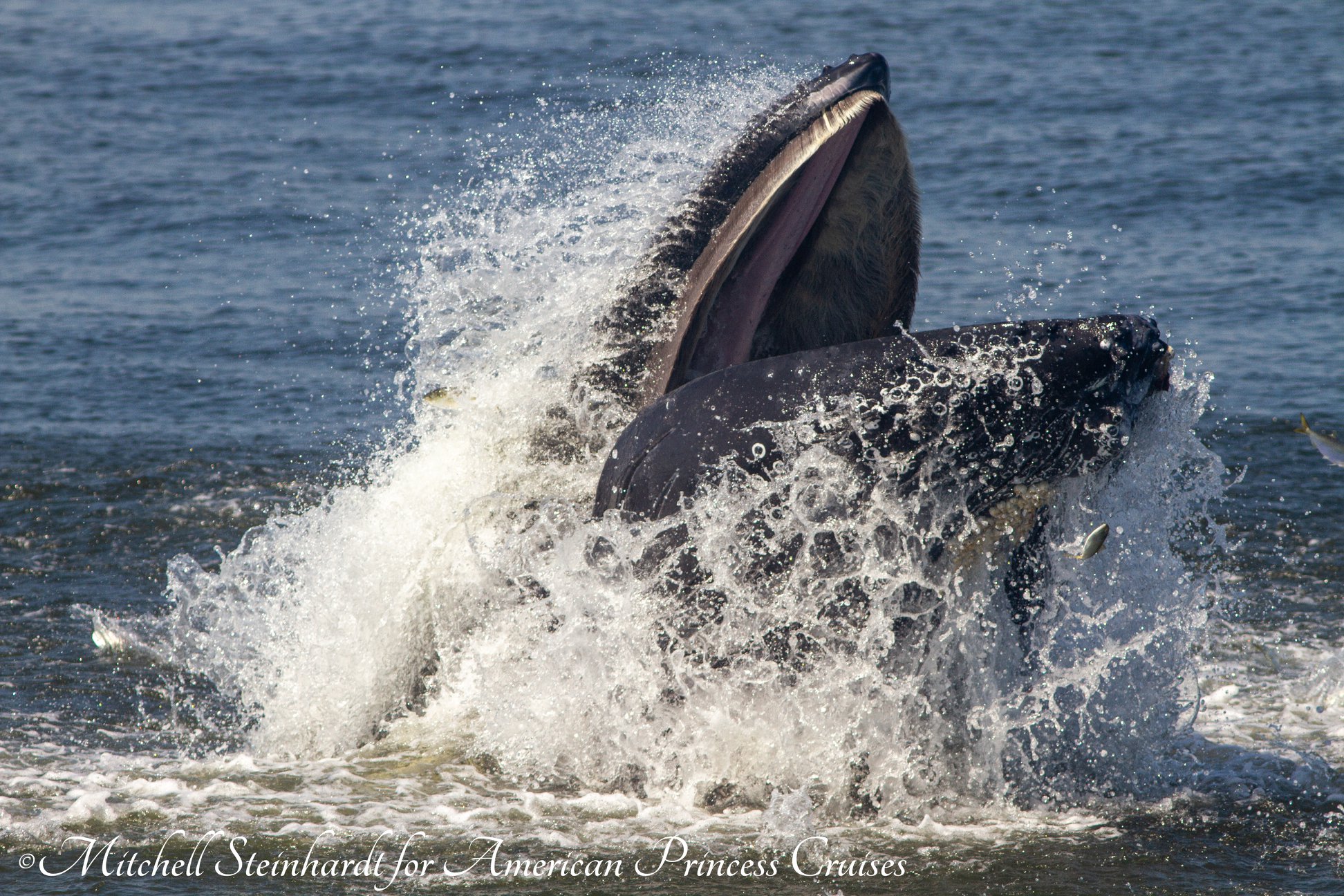
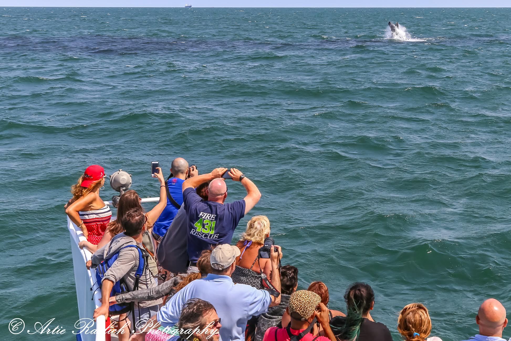
Finally, just three weeks ago, the American Princess whale watching tour was permitted to re-open as Covid-19 restrictions were lifted. Gotham Whale is a not for profit organization that routinely accompanies the American Princess into the New York Bight to catalog all ocean mammals. Their naturalists are happy to report many sightings so far this year.
THE MENHADEN SLAUGHTER IN THE NEW YORK BIGHT
But there is a war taking place in the waters along the United States East coast. For most of us living in the metropolitan area, we know little about it. The Atlantic Menhaden has been a staple bounty for one specific company whose trawlers come out of Virginia to cast their nets into the New York Bight. The Omega Protein Company, part of a conglomerate owned by Cooke, a Canadian firm, is responsible for removing millions of menhaden from our waters every year. Menhaden is targeted as it accounts for the greatest source of omega fish oil, livestock feed, and other desirable consumer goods. The main use is for feed for Cooke’s fish farms around the world.
When New York Harbor Channel first interviewed Paul Sieswerda of Gotham Whale three years ago, we learned of his organization’s effort to not only catalog ocean mammals, but reduce the menhaden fishing quota presently allowed by the Atlantic States Marine Fisheries Commission. Like all commercial operations that rely on government regulations, the Menhaden Fisheries Coalition has at least two dozen large ocean fishing companies within its ranks. This organization has traditionally lobbied and influenced the governing body to allow an excessive slaughter of menhaden.
GOTHAM WHALE PETITION TO STOP THE OMEGA FLEET
For casual fishing enthusiasts, divers, boaters, and admirers of the sea, it is important to get involved to protect your environment. Establishing a manageable program for forage species of fish is essential. You can sign any number of petitions that have been circulated to help maintain a healthy menhaden population in the New York Bight to allow the ecosystem to thrive. Gotham Whale is dedicated to the sea life that calls the New York Bight home. Here is the link for Gotham Whale’s petition to stop the Omega Fleet from over-fishing our waters.
Gotham Whale is aligned with other ecological preservation groups to prevent the collapse of the species in northern waters such as the Menhaden Defenders. The national organization called the Theodore Roosevelt Conservation Partnership (TRCP) is also concerned with saving the menhaden, with greater emphasis this year in the waters outside the Chesapeake Bay where the fight for menhaden is just as important. TRCP lobbies to influence reduced caps and put in place Ecological Management that will consider the impact on other species by fisheries managers.
These alliances will hopefully bring greater weight to the fight within this decade. In doing so, ocean mammals will no doubt flourish in New York waters and more of us will be able to share their magnificence just outside of New York Harbor. The ask of Gotham Whale is to establish a prohibition of industrialized fishing for menhaden within twenty miles from New York Harbor, an area where we know whales feed. A small step to keep a healthy ecosystem in the New York Bight.
The post IF YOU LIKE MANHATTAN, YOU’LL LOVE MENHADEN (for fishing around NY Harbor) appeared first on New York Harbor Channel.
]]>The post City Sail Preps for Virtual Classes on Teaching Children How to Sail appeared first on New York Harbor Channel.
]]>
City Sail’s Director, Soo Kim, has assembled three former students to Captain the Class of 2020. With covid-19, you can imagine the challenges of teaching 32 teens. So the decision was to create a virtual classroom that the students would learn the basics on the City Sail YouTube channel. Once the students learn the ropes online, they will be ready for small, safe groups to take their knowledge onto the boats and sail the harbor with the instructors at the helm.
New York Harbor Channel was fortunate enough to capture Soo and his instructors at the New City Kids facility in Jersey City as the virtual online videos were being produced. The tutorial videos are currently being viewed by the students and their time to board the sailboats is fast approaching. City Sail has one Colgate 26′ and the rest of the craft are donated by local boat owners who are happy to offer their time and resources.
Get to meet the sailing team and hear their pride as they tell their own personal success stories during our interviews. You will be pleased to know that New City Kids all participate in their acclimated music program. These sailors take their music on the water and the water feeds their inspiration to create musical compositions. Take a listen! If you happen to be around the harbor this month, don’t be surprised to hear a impromptu concert as the students tack their way into a bright, healthy future!
We wish you fair winds and following seas, Class of 2020!
The post City Sail Preps for Virtual Classes on Teaching Children How to Sail appeared first on New York Harbor Channel.
]]>The post HOW THE UNITED STATES CELEBRATED INTERNATIONAL HYDROGRAPHY DAY appeared first on New York Harbor Channel.
]]>The word ‘Hydrography’ means underwater mapping. This one hundred year old institution grew from the 16th century explorers of the New World. Each ship brought cartographers with them so the maps would prove the existence of a new claimed territory. Of course the map served to make return trips possible by identifying landmarks and bodies of water as well as marking dangerous locations and hazards.
The earliest tools of measuring the depth of bodies of water was a piece of stone or lead tied to a string. Early civilizations like Ancient Greece or Nordic Vikings used measurements for their ports, but it took the British Royal Navy to establish the position of Hydrographer of the Navy in 1795 to standardize the depths of the most traveled coastlines. The term ‘fathom’ was used by the British Admiralty in 1801 as six feet of rope or cable.
Not to be outdone, the U.S. Depot of Charts and Navigation was formed. It was headed by Commander Matthew Maury in 1825. Commander Maury’s work is the inspiration and precedent for the creation of the U.S. Navy’s Navoceano department. NYHC was privileged to interview the Navy crew as well as the civilian scientists working on USNS Maury in 2018 as it’s latest multibeam sonar and ROV’s were used for coastal hydrographic surveys.
NINETEENTH CENTURY WESTERN LITERATURE CAPTIVATED BY THE DARKNESS OF THE OCEANS
In 1871, a French novelist was awestruck by Commander Maury’s findings. Jules Verne must have fantasized about submersible underwater vehicles as he wrote his famous novel ‘Twenty Thousand Leagues Under The Sea’. You get the impression from the title Verne might be referring to the depth of the ocean; however, this still was not possible as ocean depth measurement was still in its infancy. Instead, twenty thousand leagues is the total distance traveled by Verne’s character, Captain Nemo and his crew aboard the fictional submarine, Nautilus. The number of leagues translates to 80,000 kilometers, almost twice the circumference of the earth.
Back in the United States, the North Atlantic spawned Herman Melville’s ‘Moby Dick’. This novel brought a monsters of the deep into reader’s bedrooms as the world slowly learned about the creatures who would magically surface only to dive to its depths once again. Captain Ahab’s unwavering pursuit of the famous but probably fictional ‘white whale’ as Beluga whales of the Arctic are white, but they are not the colossal size capable of capsizing a whaling ship.
The depths of the world’s oceans would remain a place of mystery especially to those who traveled it frequently. The love of trans-Atlantic voyages would occasionally pull vessels to the ocean’s floor. Newsreel features showed seasoned passengers on Ocean Liners such as RMS Titanic swallowed by mishap. Who could imagine an iceberg sinking a ship?
THE WORLD BEGINS TO MAKE SENSE FROM OCEAN SCIENCE
International political turmoil prevented uniformity in ocean transit and measurements. Finally, in 1921, there was an effort to establish consultation between national governments for safe navigation, technical standards and the protection of the marine environment. The world’s waterways did begin to follow common guidelines as coastal surveys became the norm for international shipping.
The second half of the 20th century developed submarine technology that spawned manned and unmanned submersible vehicles that descended to the depths of the ocean collecting digital hydrographic data. The French explorer, Jacques Cousteau, made for spectacular television viewing in the 1970’s with weekly episodes of underwater scientific adventures. For those of us who watched his series, Cousteau opened our eyes to the discoveries of his exploration team members and the instruments that seemed to roll out of production on a weekly basis. The Cousteau Society mission has found itself alive and well today in Fabien Cousteau, Jacques’ grandson, as he pioneers underwater habitats that may be the predecessor of cities of the future.
Planet Earth’s new frontier is the ocean floor as it is now as popular as space exploration. Fifteen years ago, the United Nations hosted the member countries of the modernized initiative called the International Hydrographic Organization (IHO). The UN assembly adopted a resolution for the entire planet to celebrate World Hydrography Day every June 21st. This year’s theme is “Enabling Autonomous Technologies”. Next year, 2021 will mark the one hundredth anniversary of the creation of the original Hydrography Organization that was comprised of multiple nations around the world.
THE U.S. CHAMPIONS OF HYDROGRAPHY ACKNOWLEDGE INTERNATIONAL HYDROGRAPHY DAY
Aside from the U.S. Navy’s Navoceano program, the most dedicated agency is the National Oceanographic and Atmospheric Administration (NOAA). NOAA is divided into various sectors of study. Meteorology is most visible as it deals with weather and weather events such as hurricanes. NOAA also operates its Fisheries sector and it includes the Ocean Exploration and Research (OER) branch.
OER’s newest hydrographer, Dr. Sam Candio, paid homage to the IHO on International Hydrography Day. He mentioned sonar devices are helping define the marine world, but only one fifth of the ocean floor is mapped. He looks forward to being a key player in NOAA’s participation of this exciting frontier.
The IHO gives the world an opportunity to pull back the curtains and reveal each country’s self-serving interests in hopes of incorporating them into a shared, glorious, global plan. The world oceanographic industries do have a reason to celebrate. Measurements will not be propriety. Everything will be shared. The cost of technology is shared.
U.S. NATIONAL MARITIME DAY IS CELEBRATED ON MAY 22ND DRIVING THE NEED FOR HYDROGRAPHY
In 1933, the U.S. Congress created a national holiday that honored the first U.S. steamship to make a trans-Atlantic voyage in 1819. Holidays such as these strengthen a sense of national pride, however, they do little to allow international efforts, blinding us to see the larger picture taking place on a global stage.
The United States carefully watches the shipping activity of its ports. International container goods shipped around the world is approximately 1.8 billion metric tons. With these kind of numbers, Is environmental protection the driving force behind measuring the ocean depths? Well, yes it can. Advocacy groups have helped shape the establishment of dozens of government agencies that do protect marine ecosystems and sea life.
The Obama Administration created Monuments as protections of fragile habitat zones and established marine sanctuaries; however, the Trump Administration is striping those protections. Preservation advocacy groups convinced the Obama Administration to mandate the Environmental Protection Agency (EPA) to strictly regulate fishing and exploration in the entire Northeast Canyons and Seamounts Marine National Monument (NCSMNM) area as it was recognized to be a spawning ground for species essential to supporting and sustaining marine life along the North Atlantic coastline.
If the present U.S. administration has it’s way, this apparent romantic notion may be outweighed by the greater force of marine commerce and the exploitation of natural resources under the ocean floor. It must also be noted that this administration has no desire to actively participate in the IHO as the President clings to an ‘America First’ decree. There is not a single American in the IHO executive committee. The future is a shimmering stardust in the specter of autonomous transportation initiatives. Somehow, NOAA scientists hang on to the dreams and desires of the past administration.
NOAA SOON TO ENTER ITS THIRD DECADE OF DEEP WATER EXPLORATION
As the world is increasingly comfortable with operating submersibles, ROV’s are entering uncharted regions in record numbers. Not only are military and governmental agencies lowering these essential automated tools into the oceans, private foundations and commercial industries are busy at work on a multitude of missions. NOAA’s Ocean Exploration and Research (OER) is quickly logging two decades of exploration data.
What was NOAA’s closest deep sea exploration to the U.S. Eastern coastline? New York City should be proud to know that less than one hundred miles southeast of the Verrazzano Bridge, the Hudson Canyon Expedition was successfully mapped and researched in 2002. Dr. Peter Rona, then a professor at Rutger’s University, was lead scientist aboard the NOAA Exploration ship, Ronald H. Brown. High definition cameras caught images of the canyon floors revealing deepwater corals, sponges, and species never before seen. The depths of the canyons fall three miles below the surface of the New York Bight. Seismic reflection profiling was used to map the canyon. Since then, this controversial method has become a major subject of protest by environmental advocacy groups. Seismic blasting has given much evidence of the harm it causes to marine mammals and the ecosystem in general.
BATHYMETRIC DATA COLLECTION SPAWNS A DOZEN ACRONYMS TO ACHIEVE ONE GOAL
Over the past decade, multiple data-collection programs created multiple data results. With one fifth of the earth’s ocean bottom mapped, the end-product is questionable. Nonconformity has obvious flaws when it comes to science. The IHO is spearheading the international effort to conform to one agreed protocol for all to standardize the methodology and instrumentation.
ASPIRE is the acronym for the Atlantic Seafloor Partnership for Integrated Research and Exploration. A centralized, shared protocol to unify independent underwater data acquisition and established qualified and quantified databases of the ocean floor. The Galway Statement has successfully joined forces between the United States, Canada, and the European Union nations to initiate programs in the North Atlantic to do just that.
Another collaborative initiative is called Seabed 2030 to standardize and furnish authoritative data available to everyone. It’s goal is to help make policy decisions based on the bathymetric information. NOAA’s National Centers for Environmental Information (NCEI) division data base is already accessible to agencies and the general public.
ASPIRE and Seabed 2030 are foundations of NOAA’s latest hydrographic study as it is tackling the deep canyons of the North Atlantic.
TWENTY PRIORITIES RESULTING FROM THE 2018 CALL FOR INPUT WORKSHOP
On November 16th, 2018, NOAA summarized their Exploration Science Planning Workshop. The “Call for Input” netted 50 deep sea experts to discuss their ideas and concerns for regional exploration priorities in the Mid-Atlantic Ridge. Here is the summary of twenty exploration subjects planned for the 2019 & 2020 expeditions….
1. Marine mammal habitats
2. Water column exploration for Beaked whale feeding and spawning grounds in seeps of the Northeast Canyons and Seamounts Marine National Monument (NCSMNM)
3. North Atlantic Right Whale transit in the Laurentian Channel
4. Seeps in the Laurentian Fan
5. A proposed marine park in the Laurentian Fan
6. Fisheries and benthic habitat assessment in the Halifax Line
7. Unknown fauna of The Gully
8. Unknown canyons
9. Submarine landslides in the Laurentian Fan.
10. Geohazards
11. Deep-sea coral and coral conservation areas
12. Sponges in the Seamounts
13. Deep-sea mining interests
14. Fisheries habitats and interests
15. Underwater Cultural Heritage surveys
16. Shipwrecks offshore of Boston and New York
17. USCGC Bear search with high-resolution mapping using AUV
18. Cold-water coral communities in the Gulf of Maine
19. Partner with existing marine geophysical surveyors for oil and gas exploration in the Grand Banks and Flemish Cap region. Multibeam bathymetry coverage for critical mineral inventory initiatives.
20. Resurvey of the RMS Titanic using new archaeological devices and methods.
THE NOAA OCEAN RESEARCH VESSEL, OKEANOS EXPLORER

Okeanos Explorer’s home port is North Kingstown, Rhode Island. It utilizes the latest exploration tools such as multibeam sonar, telepresence, water column investigations, and underwater robotics. Two Remotely Operated Vehicles (ROV) submersibles on Okeanos are Deep Discovery and Seirios. According to NOAA’s OER, Okeanos is “the only federal vessel dedicated to exploring our largely unknown ocean for the purpose of discover and the advancement of knowledge about the deep ocean.”
THE 2019 EXPEDITION ONE HUNDRED MILES FROM MONTAUK
Ground Zero for residents of the Mid-Atlantic and Northeast region of the United States, is the Northeast Canyons and Seamounts Marine National Monument (NCSMNM). NCSMNM is 5,000 square miles of underwater terrain and it is as deep as the Grand Canyon. It sits 100 miles south east of Cape Cod and Montauk Point. This deepwater sanctuary remains mostly unexplored. Thanks to NOAA, here are some Images of the submarine breathtaking landscape from the Okeanos Explorer study.
Two of the 2019 Okeanos Expeditions were called “Deep Connections” and “Windows To The Deep”. They featured Biodiversity hotspots as it proudly broadcast the existence of Bubblegum Coral in Gully Canyon during one of its many live NOAA webcasts. Other webcasts allowed the NOAA audience to watch as the ROV slowly examined the face of a sheer cliff wall with no variance, truly a massive Massive. The Okeanos crew repeatedly mentioned the beauty that has no boundaries between the borderlines that separate Canadian waters from the Untied States. The underwater regions are seamless as the ecosystems expand and transit beyond the man-made boundaries above. This is a stellar picture of hope and optimism.
A PARODY OR A PARADOX
NOAA is surrounded by storm clouds. A politically-inspired storm field that is interwoven within NOAA’s very fabric, its very existence. Since 1971, the NOAA emblem clearly stated it is connected to the U.S. Department of Commerce. The DOC is currently headed up by Wilbur Ross, a man who has risen through the ranks utilizing fossil-fuel industries as his backbone. Ironic that the very organization that prides itself as the people’s voice that tries to stop the advancement of fossil fuel reservoirs under the ocean floor is captained by a man whose hands are mired in it. The outwardly visible side of NOAA is glowing with environmentally friendly, science-based, and thought-provoking initiatives intended to lessen fossil-fuel dependency. NOAA Fisheries is a shining tower, the pinnacle of progressive, earth-minded thinking. However, it’s subservience to the DOC cannot be ignored. The powerful mandates that arise from the DOC’s cellars are hypnotic and unquestionable. The paradigm is this. NOAA is all about protection. DOC is all about mass economic undersea mining and self serving plundering of the ocean’s riches.
Meanwhile, the Environmental and Energy Law Program of Harvard University has carefully monitored recent activities that affects the waters not far from it’s Cambridge, Massachusetts campus. Harvard carefully followed President Trump’s executive order #13795 signed into effect on April 28th, 2017 that instructed immediate review by the Secretary of Commerce of the protection of Canyons and Seamounts as it was a watermark of the Obama Administration in 2016. The executive order instructed Wilbur Ross to assess the opportunity costs associated with potential energy and mineral exploration in this area.
It wasn’t long before environmental groups such as Oceana quickly sued the DOC. Using the Freedom of Information Act, Oceana stated the DOC failed to disclose actual initiatives in hopes of forcing the administration to reveal its secretive plans for resumption of offshore drilling and deregulated commercial fishing. This and other lawsuits have sidelined the government’s desire to activate oil and gas surveys. The independent seismic testing vessels were denied operation.
And yet, with all of the drama swirling around within DOC, it was as if Moses parted the sea to allow the single NOAA ship to motor out into the Northeast Canyons and pursue their solo mission in otherwise turbulent political waters. Half of the Okeanos mission was accomplished before the approaching winter of 2019 closed down Okeanos operations. The ship returned to Rhode Island for retrofit and repairs. The samples and data were inspected and the crew sat out the season waiting to resume in April of this year.
AS A PLAGUE SETTLES OVER AMERICA, THE EXPLORATION AND ITS D.O.C. TENTACLES ARE ON HOLD
Okeanos Explorer is halfway through it’s seafloor mapping mission of the NCSMNM. Additional exploration and mapping was scheduled for this August to mid September. Covid-19 has paused the operation until further notice. Once the mission is given the green light to resume activity, the concentration for this year’s survey will focus on the Sohm Plain. Flat ocean bottoms are the kind of terrains of most interest to the oil and gas industry.
Out of the blue, President Trump’s June 5th Proclamation was announced before an audience of Lobstermen representing the Commercial Fishing Industry at the airport in Bangor, Maine. The Proclamation immediately opens the Northeast Canyons and Seamounts Marine National Monument protected area to large-scale trawling. This is the very region that NOAA recently touted its mandate to reasonably manage fishing based on scientific study. It is no coincidence the Proclamation cites a healthy increase in the populations of species that were of primary concern to ensure protection. Neil Jacobs, now famous for his role in Sharpie-gate, has issued a dubious statement claiming the harm to whale species does not rise to “a population level consequence for the species.” Jacobs mouths the Trump administration credo that the United States must be energy independent.
The Fossil-fuel industry supports EPA Secretary Wheeler’s proposal to rollback Obama protections and allow shortcuts for businesses to bypass regulations such as Clean Air Act of 1970 and Climate Change regulations. On the surface, top NOAA officials have unilaterally reversed direction in favor of compliance with other federal administration officials within the DOC. It is an understatement to say the Proclamation overrides NOAA’s carefully formulated plans this year. The light-minded thinkers of NOAA can only wonder how their mission will continue unimpeded as commercial fishing vessels are now allowed to drop their nets into the very depths they are trying to protect.
Just a few weeks ago, a National Strategy for Mapping, Exploring, and Characterizing the United States Exclusive Economic Zone was distributed this month by the President’s Ocean Policy Committee. To the uneducated mind, there seems to be a veiled reference in section 4.2 to “create a market for commercially developed technology applications” with the inclusion of “external partners”. In section 2.1 seabed backscatter acoustic imagery and sub-bottom profiling” is communicated, but seems to be vague. There are methods expressly outlined for ocean floor testing; however, they are not specifically referenced as the only methods currently available or specifically utilized.
Will NOAA be using Passive Acoustic Monitoring (PAM)? The International Association of Oil and Gas Producers funds PAMguard software created by Sea Mammal Research Unit at the University of St. Andrews.
Meanwhile, five seismic testing companies have been green-lighted to perform the controversial mapping method on the Outer Continental Shelf in the North Atlantic. It is no coincidence that just last week, the federal government overruled North Carolina’s case that tried to stop the testing forty miles off the outer banks. This area, known as ‘The Point” is a massive habitat for marine species. The endangered Right Whales and Cuvier’s Beaked Whales are extremely sensitive to the seismic blasting. The Bureau of Energy and Management (BOEM) rescinded its previous decision three years ago in favor of granting the permits.
It is obvious that NOAA continues to operate critical global initiatives with one hand tied behind its back. NYHC has attempted to contact officials at NOAA for comment on it’s policy on seismic testing. We have yet to receive a reply.
SUSPENSE THRILLERS OF THE 1980’S MAKE A COMEBACK
There are two motion pictures that come to mind as we witness the paradox unfolding at NOAA. One is Star Wars Episode V and the other is Hunt for Red October. Both movies offer a psychological window into the schizophrenic drama playing out between the DOC and NOAA. Interestingly enough, the brilliant American actor, James Earl Jones, is in both of them.
I cannot help but hear James Earl Jones’ voice-over for the Darth Vadar character as the haunting black-robed figure wearing a veiled helmet and respirator, menaces, “You don’t know the power of the dark side! I must obey my master.” Can you envision Wilbur Ross standing over a cowering researcher on the gangplank of Okeanos? Lord Vadar pleads with his son, “Come Luke, Come to The dark side.”
Then, in the 1990 movie, Hunt For Red October, James Earl Jone’s character, Admiral James Greer famously says, ” That torpedo didn’t self-destruct, you heard it hit the hull and I was never here!” as the submarine mission takes a solicitous turn of international detente. A meeting inside the DOC could easily adopt this scene.
It is not too far a stretch to align Captain Nemo, Captain Ahab with Admiral Greer and Lord Vadar. Despite their being a century apart, all four of these characters face their inner souls during a critical time in their mission. Hopefully, they choose wisely. We can only hope the same for our cast of characters that hold the future of our seas in their hands.
CONCLUSION
Diving down within the US Economic Exclusion Zone, the haunting question is when is the seabed surveys allowing commercial exploration? Thanks to the virus and the exploration halt, the stoppage has bought some time. Despite, declining call for seismic blasting technology over the past five years, the gas and oil exploration industry continues to develop more sophisticated instruments to enhance the controversial marine geo-physical survey technique. 4D imagery is now available as well as floor mounted devices that can be remotely activated in a field that may require periodic use of seabed inspection.
The meaning of International Hydrography Day is quite simple. It is a moment to recognize the good work the entire world can participate in. It serves everybody. And everybody should be excited by it. The mapping of the ocean floor is a signal of the future. In these times when the world should come together, it should not be taken as a signal that threatens the United States into formulating a self-serving credo.
The post HOW THE UNITED STATES CELEBRATED INTERNATIONAL HYDROGRAPHY DAY appeared first on New York Harbor Channel.
]]>The post WANTED! CITIZEN SCIENTISTS FOR THE GOTHAM WHALE CATALOG appeared first on New York Harbor Channel.
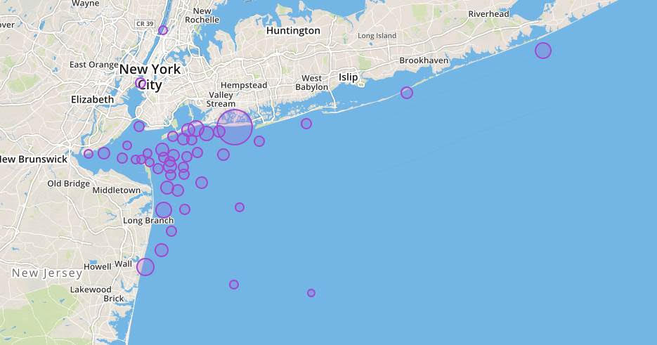
]]>New York City Whales are a reality. Two Woods Hole Oceanographic Institute (WHOI) detection buoys confirm the steady presence of Fin, Sei, Humpback, and North Atlantic Right Whales in the New York Bight, the area just east and south of New York Harbor. This month, humpbacks are ever-present. So much so, sadly, one washed up on Jacob Riis beach. It is suspected to have been a newcomer to the area or at least it was not cataloged in the local marine mammal data base.
Whale watching has become a steady business for the operators of the American Princess based in Far Rockaway. They maintain a regular schedule of whale watching tours where a local naturalist and an apprentice or two are part of the excursion. Their experience and knowledge of sea life in and around the local waters educates the ship’s audience.
One such marine enthusiast is Mitchell Steinhardt. His knowledge of the
local sea life in the New York 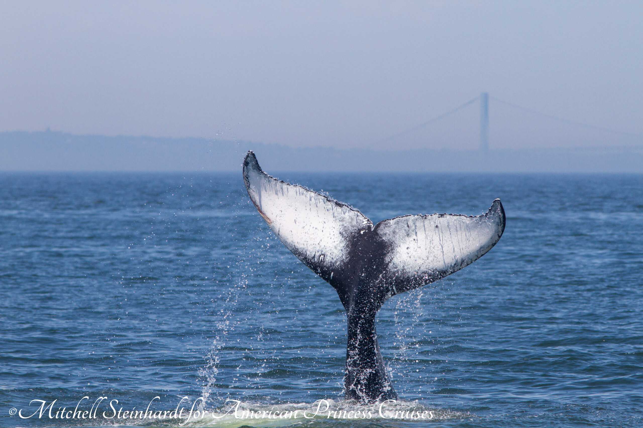 Bight is captured in his photography. But you must understand that the tour is not only for the whale watching experience. The spotting of marine mammals is a science. Photography not only offers the possibility of award-winning pictures, for Paul Seiswerda of Gotham Whale, it is a necessity to keep a catalog viable.

Gotham Whale is a source of education, advocacy, and science for the inhabitants of New York, terrestrial and marine. It contributes to the improving health of New York’s marine environment, for the betterment of both humans and whales. Paul and his team inspect the photos and updates the data base. He catalogs returning friends or better yet, new ones. It’s the new ones that excite him most, as it is a new number or a nickname based on characteristic markings on the fluke, fins, or face kept in Gotham Whale’s New York City Humpback Whale Catalog. Gotham Whale also tracks the numerous seals and dolphins that call New York home.

But Covid-19 has temporarily shut down whale watching tours. The American Princess is tied up at the Breezy Point dock. Even if the ship was to re-classify itself as a research vessel, the lack of paying customers would not be enough to overcome the operating cost. The tourists have disappeared. So has Gotham Whale’s main avenue to catalog the New York Bight marine mammals. Paul is worried the entire 2020 Whale Watching season will be cancelled.
CALLING ALL CITIZEN SCIENTISTS!
Gotham Whale must turn to alternative methods to get their data this season. Enter the Citizen Scientist, a hardy marine lover who may be a local kayaker, canoer, sailor, jet-skier, or fisherman. While these adventurous souls are out on the water, there is a good chance they will encounter the very mammals Paul is looking for. This also applies to sea captains of the large cargo and cruise ships as well as the many support vessels that work New York Harbor such as barge tugs.
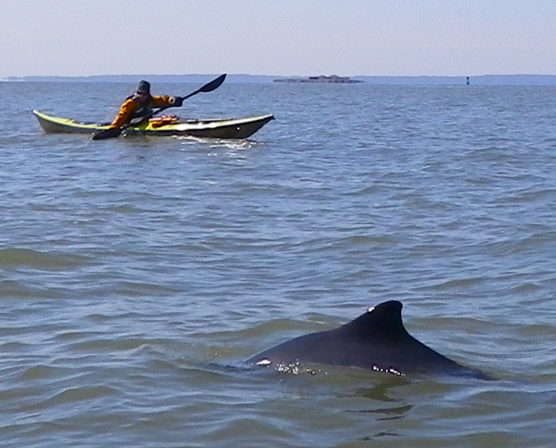
As marine mammals are migratory, it is important to track their movement on a daily basis. New York has recently reopened marinas so the chances are good that boaters will be passing Jamaica Bay, Staten Island, or Sandy Hook. This sea triangle forms the region where whales, dolphins, and seals thrive.
WHAT YOU CAN DO!
You can be Paul’s ‘eyes on the water’. Imagine the excitement of your observation at the time of sighting. Was that whale feeding? Was there a pod of whales? Did you observe a baby calf? Your cell phone automatically gives the latitude and longitude of your location as soon as your picture is taken. There you go… you are already a Citizen Scientist! Welcome to the club!
So Paul is asking any boater to be on the lookout. If you do have an encounter, please send your photo to [email protected]. Not only will you be helping the preservation of these endangered creatures, you will also get a first hand education of what kind of animal you encountered. You will forever be credited with your submission for Gotham Whale’s 2020 catalog. We thank you in advance for doing something special for the waters of the New York Bight.
Gotham Whale is a not-for-profit organization and donations for their tireless work are always appreciated.
The post WANTED! CITIZEN SCIENTISTS FOR THE GOTHAM WHALE CATALOG appeared first on New York Harbor Channel.
]]>The post Great Women Sailors come to New York Harbor appeared first on New York Harbor Channel.
]]>
Here in New York, Captain Nitzan Levy is offering her expertise to promote initiatives focusing on young women who have an interest in learning to sail in New York’s waters. Nitzan, a social entrepreneur who started her cruising club in the NY Harbor 7 years ago actively participates as a competitive sailor. She is no stranger to off-shore sailing regattas.
Nitzan has been influenced by many women before her and she will be celebrating some of their efforts in this month’s series on Women Who Sail. For one, Tracy Edwards will be recognized this month in a series of interviews published over the next eight weeks.
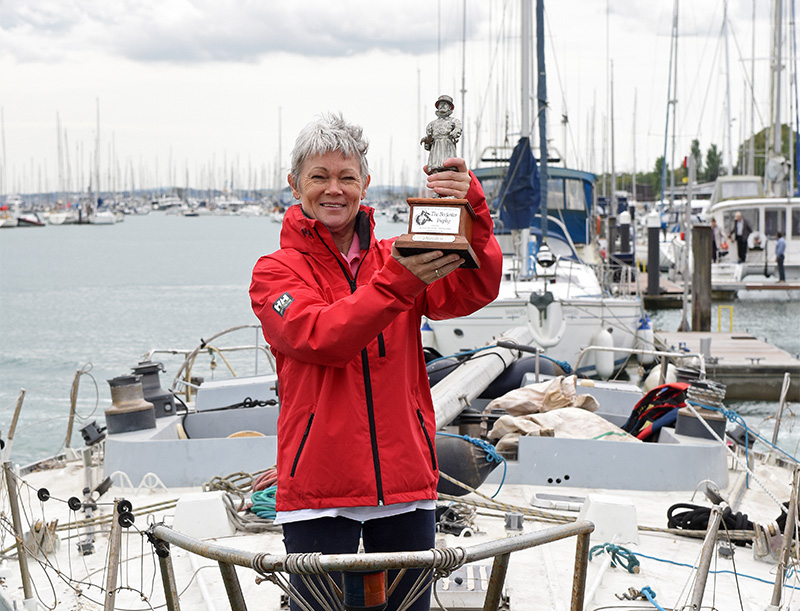
Tracy Edwards’ all-female crew of Maiden won her a berth in the history books. The 2019 documentary, ‘Maiden’ poignantly depicts the story of how Tracy found the yacht, assembled the crew, and endured the race as a finalist in the Whitbread Around the World Race in 1989. Her passion is worthy of inclusion as a celebrated sports representative.
Nitzan and the New York Harbor Channel preludes the arrival of The Maiden Factor to New York Harbor. You can learn more about Tracy Edward’s history and new foundation by following us here.
The post Great Women Sailors come to New York Harbor appeared first on New York Harbor Channel.
]]>