A NYC resident looking at a public information poster titled "New York City Hurricane Evacuation Zones". This map is a tool used by the city to inform residents about potential coastal storm hazards and preparedness.
New York City’s waterfront is dotted with construction cranes towering over the crews that work on the jobsites and the marine barges anchored adjacent to them. This is a multi-billion dollar collection of separate infrastructure projects all under the auspices of the NYC Department of Design and Construction (NYCDDC). Standing on a Brooklyn rooftop in DUMBO, the view of Manhattan’s waterfront runs well north of the Brooklyn Bridge from Stuyvesant Park ferry dock at East 20th Street down to Manhattan’s southern tip at Battery Park. It bustles with construction activity. A little less, here on the Brooklyn side of the harbor.
The total area is more than two miles of NYC coastline. This overall civic initiative has one purpose; to prepare for the next tidal surge and prevent an imminent rise of sea level that will affect New York Harbor. The initiative is to cope with a possible 100 year storm event predicted to occur sometime before 2050.
In a recent conversation with Ian Michaels of NYCDDC, the various aspects of the mega-project was stripped down to the essentials. Coastal Resilience is the phrase describing the physical alteration and redevelopment of NYC’s low lying residential neighborhoods or commercial districts that experienced the full wrath of Superstorm Sandy on October 29th, 2012. The first project started in Manhattan was the East Side Coastal Resiliency (ESCR) Project. The second site in Manhattan is called the Brooklyn Bridge – Montgomery Coastal Resiliency (BMCR) Project that runs from the bridge up to Montgomery Street. A third site in Manhattan is the South Battery Park City Resiliency Project, and just starting now is the Red Hook Coastal Resiliency Project located south of DUMBO in Brooklyn’s Atlantic Basin.
The 2012 Event That Started It All
In the last fall week of October, 2012, as families were busy preparing for Halloween festivities, news of an approaching tropical storm was not only of regional interest, but internationally as well. NOAA forecasters were confident New York City was going to bear the brunt of a major coastal impact. With that, Mayor Michael Bloomberg proclaimed evacuation orders for Zone A, but also instructed city workers to continue preparations and street adornments for the NYC Marathon scheduled for the following week.
Hurricane Sandy had sustained winds of 95 miles per hour. Forty-four city residents perished. Thousands of buildings, tunnels, and subways flooded. Neighborhood grocery and supermarket food spoiled. Con Edison power generating station outages lasted days. The sea water that was pushed onshore stood high on city streets. As the storm moved out to sea, leaving devastation behind, Mayor Bloomberg ran the city from the Office of Emergency Management.
Fourteen years later, most of us can only imagine the magnitude of the response effort assembled in those darkened rooms of City Hall. The remnants of Superstorm Sandy is still evident today as corrosion of cables, pipes, electrical components and infrastructure under NYC streets require upgrades and replacement.
Few people living within one hundred miles of NYC had power, let alone time to watch television or internet if they were even fortunate enough to have it. Fallen trees alone in the outer boroughs and suburbs accounted for electrical outages. Some communities reported outages lasting 13 days. To top off the hardship of the Halloween Hurricane, it snowed, and temperatures dipped close to freezing. News stories were shared by mouth, not through the airwaves.
THE 2012 SANDY RESPONSE, RESCUE, AND RECOVERY
New York City’s budget included funding for disaster response, relief, and reconstruction. As the storm moved out to sea, NYC communication was hampered; however, prior to Sandy’s arrival, multiple strategies were already employed. The predictions of the magnitude of the devastation became a shocking reality in the following hours. The Army Corp of Engineers had already geared up equipment for the removal of debris and materials. Roughly 3.6 million cubic yards of debris remained after Sandy’s departure. It was said to be enough to fill about seven Yankee Stadiums. After the recyclables were sorted, the rest was transported to landfills using barges.
FEMA workers were tasked to perform search and rescues in low lying areas where casualties already mounted. No less than seventy evacuation shelters were operational with food, water, heat, and electricity on stand-by. Task Force Power included hundreds of soldiers from the 249th Engineer Battalion in addition to Corps civilians from Temporary Power Planning and Response Teams. Approximately two hundred FEMA generators providing 54 megawatts of power were needed to support 25,000 NYC residents.
Other outfits, such as Army’s 86th Engineer Dive Detachment, the 76th Engineer Company, and the Marine’s 8th Engineer Support Battalion conducted engineering and structural assessment of damaged piers, waste water treatment plants, and Housing Authority apartment complexes where pumping out seawater was necessary. The Unwatering Task Force began running its miles of hoses to pump the streets and subways of 500 million gallons of seawater. Engineers supervised the slow “Gravity drain” of the Brooklyn Battery Tunnel so the walls didn’t collapse.
The cost to NYC for the post-Sandy clean up and recovery has a price tag of 19 billion dollars. To date,14 billion dollars has already been paid to contractors. It is anticipated current and future work will continue at least five more years, well into 2030. Aside from the continued infrastructure repairs and upgrades in affected NYC areas, NYC’s Build-It-Back housing project and the coastal resilience is still being funded until completion.
MAKING THE GATES OF TODAY’S COASTAL RESILIENCY
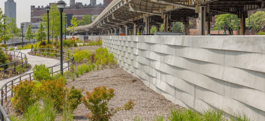
As intentionally designed post-Sandy, the new gates are tucked neatly and inconspicuously inside the belly of pristine playgrounds, sport fields, and berms of the extensive waterside public parks. They hide the deployable mechanical structures that await activation. The public space is now elevated at least ten feet higher than their original contour to contain a rising sea level. The redevelopment includes the floodwalls now featured in the parkland.
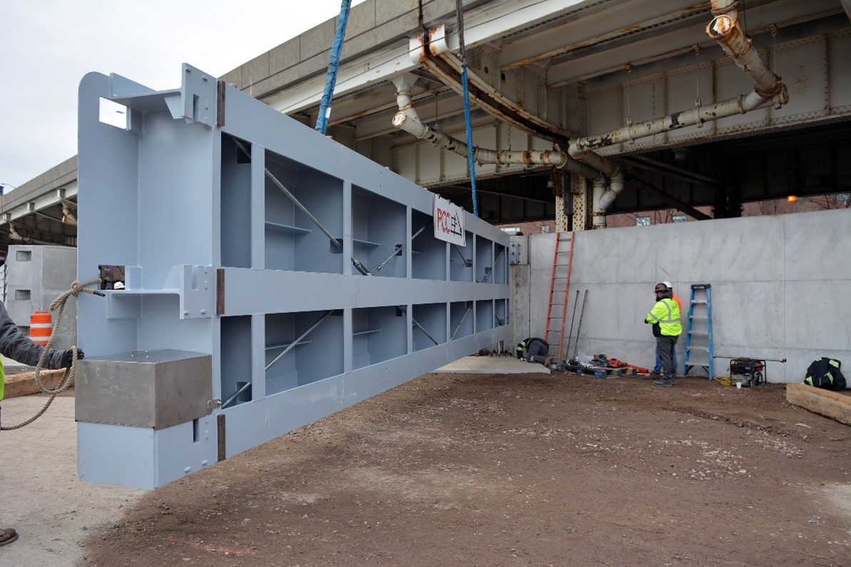
The ESCR and BMCR projects both use hydraulic “flip-up” gates that were manufactured by FloodBreak Corp. As seen in the picture, the gates are 13 feet tall by 40 feet long. The “flip-up” floodgates lay flat in the ground and are considered usable space allowing pedestrians to walk over them. These are found in ESCR’s Asser Levy Playground and Pier 42.
Additionally, for this project requirements, Linita Design & Mfg Co. created the thirty two thousand pound movable roller flood gates, each measuring forty feet long and ten feet tall. Once all projects are completed, there will be a total of eighteen used for all the projects. Steel and aluminum construction will combat the intense water pressure that surrounds them during a flood occurrence.
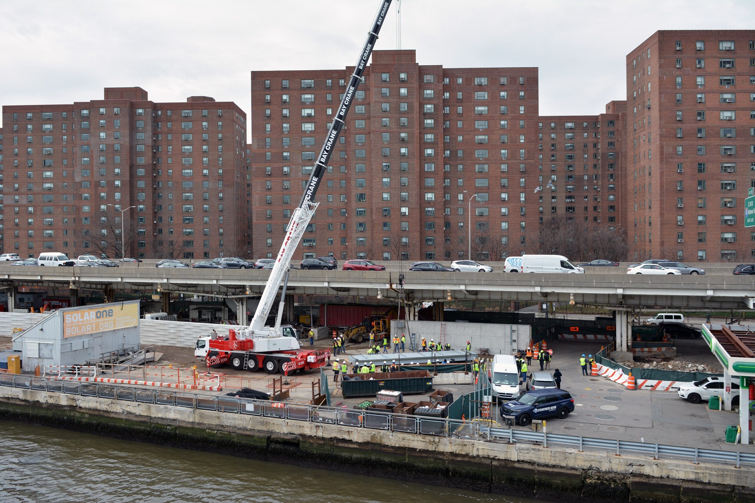
A 197-foot-tall Liebherr LTM 1130 crane prepares to lift the first 32,000-pound flood gate into place as part of East Side Coastal Resiliency
he first ESCR flood gate in place. The gate will remain open but can be closed in anticipation of storms or future flood events to protect 110,000 Lower East Side residents
WHAT PROJECTS HAVE BEEN COMPLETED?
Fourteen years later, we now see a picture of serenity with the completion of ESCR’s most northern location of Stuyvesant Park at the Ferry Landing. The gates are safely secured within the waterfront promenade in this less traveled section of the Lower East Side.
NYCDDC has also announced the completion of the eight hundred foot length of the Battery SBPCR flood barrier wall at the lower Manhattan tip. Here, the tide gate chambers are designed to disperse the force of tidal surge against the Battery wall. The hydraulic “flip-up” gates are featured at this location as well. Here, Battery Park offers residents and visitors enjoy recreational space that does not boast the presence of the important flood reduction features now incorporated into its structure.
A separate, lesser known improvement, but important beachfront project, not part of the NYCDDC, is the Living Breakwaters Artificial Oyster Reef off the shoreline in Staten Island. It is a natural coastal resilience project costing $111 million. Completed in 2024, such concrete reef construction is a design that may be duplicated in other beachfront and estuary locations. The design of the “Reef balls” by ECOncrete for SCAPE Landscape Architects, should allow sea life to use the structure. Hopefully, marine species look for and will reclaim a new home where the famous New York Harbor oysters once thrived. The Billion Oyster Project was involved with the reef’s creation at the Tottenville site. Tottenville is home to Sandy Bottom, a historical foundation whose heritage celebrates the black oystermen who harvested the oyster beds at this site in the 1800’s.
Out in the ocean, the Rockaway Reef is also noteworthy as a submerged artificial structure that will help slow down ocean swells from devastating the Rockaway beachfront communities during turbulent storms. Such submerged reefs not only aid physical wave damage to land, they also provide additional protections and ocean habitat to local fish and marine sea life that rely on reef structures.
Coastal resilience is now an international concern, especially for urban centers in low lying areas. Holland typifies technology that has grown from centuries of experience. New York City is now following their example as engineering firms from Europe consult on projects that are necessary to ensure a watertight future.
AD:
Custom progamming, database and system support
Best custom computer programming, database and system work.
https://custom-software-usa.com
Custom Software USA
2 COMMENTS
我为! new York is flooding?
Scientists predict major rise in sea level and more severe hurricanes and storms that will adversely affect New York Harbor.


我为! new York is flooding?
Scientists predict major rise in sea level and more severe hurricanes and storms that will adversely affect New York Harbor.